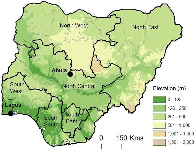
In Nigeria, geopolitical zones are the administrative divisions. Till date, Nigeria has 6 geopolitical zones, which were created in President Sani Abacha’s regime.
The country’s resources regarding educational, political, economical are often shared across these zones.
The structure of the 6 geopolitical zones in Nigeria was carved out according to states with common political history and similar ethnicity.
Nigeria has over 450 languages and 400 ethnic groups. With this vast classifications, the government decided to merge some groups together for easy allocation of resources. That’s the reason for dividing them all into 6 geopolitical zones.
These geopolitical zones include:
North Central.
North East.
North West.
South East.
South South.
South West.
South south geopolitical zones in nigeria
The South South geopolitical zone is also referred to as the Niger Delta region. It consists of six states, namely: Rivers, Delta, Bayelsa, Edo, Akwa Ibom, and Cross River.
This geopolitical zone is the country’s economic mainstream. And its population is significant.
Where was the South South region created from?
The creation of the South South was made during the regime of General Yakubu Gowon. On 27th of May, 1967, the Eastern region (made up of Rivers, Cross Rivers, Akwa Ibom, and Bayelsa) and Western region (Delta and Edo states) formed the South South region.
Nigeria map geopolitical zones in nigeria

Population of 6 geopolitical zones in nigeria
According to the figures gotten from 2006 census, the National Population Commission declared the North West geo-political zone as the most populated zones in Nigeria.
Here is a summary of the population figures based on the states in this zone:
Kano state – 9,383,682.
Kaduna state – 6,066,562.
Katsina state – 5,792,578.
Jigawa state – 4,348,649.
Sokoto state – 3,696,999.
Zamfara state – 3,259,846.
Kebbi state – 3,238,628.
It was also recorded that the North West zone has the third largest landmass in the country. Individually, there are:
Kano state – 20,680Km2.
Kaduna state – 43,460Km2.
Katsina state – 26,785Km2.
Jigawa state – 22,605Km2.
Sokoto state – 25,973Km2.
Zamfara state – 39,762Km2.
Kebbi state – 41,855Km2.
Mention the six geopolitical zone in nigeria and their state
The six geopolitical zones in Nigeria and their states are listed below:
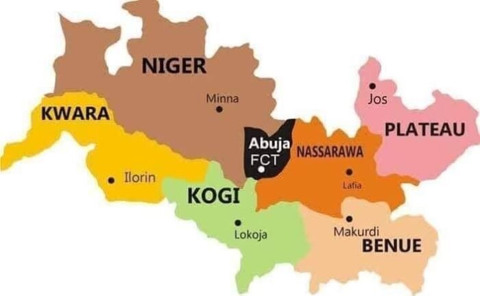
The North Central zone (also referred to as the Middle Belt region). It has 7 states: Plateau, Niger, Nasarawa, Benue, Kwara, Kogi, and FCT Abuja.
The North West zone. It consists of 7 states: Sokoto, Kano, Zamfara, Jigawa, Kaduna, Katsina, and Kebbi.
The North East zone. This zone has 6 states: Taraba, Bauchi, Yobe, Borno, Gombe, and Adamawa.
The South West zone. It has 6 states: Lagos, Ogun, Oyo, Osun, Ondo, and Ekiti.
The South East zone. This zone has 5 states, and they are Anambra, Ebonyi, Abia, Enugu, and Imo.
The South South zone. It consists of 6 states, namely: Delta, Edo, Rivers, Cross River, Akwa Ibom, and Bayelsa.
How many region in nigeria
There are 4 regions in Nigeria.
When Nigeria was about to gain her independence, Britain proposed an arrangement to divide Nigeria into four regions.
In the North was the Hausa-fulani domineer. The West was mostly of Yoruba dominant. The Igbo were dominant in the East.
According to the arrangemen, each of the key ethic groups were to controls their regions.
That’s not all. The British also ensured that 52% of delegates to the national legislature must be from the Northern Region. This was the price of making northerners support independence.
Most populated geopolitical zone in nigeria
The North West geopolitical zone is the most populated zone in Nigeria.
According to the figures gotten from 2006 census, the National Population Commission declared the North West geo-political zone as the most populated zones in Nigeria.
Here is a summary of the population figures based on the states in this zone:
Kano state – 9,383,682.
Kaduna state – 6,066,562.
Katsina state – 5,792,578.
Jigawa state – 4,348,649.
Sokoto state – 3,696,999.
Zamfara state – 3,259,846.
Kebbi state – 3,238,628.

North central geopolitical zone
The North Central geopolitical zone in Nigeria is also referred to as the Middle Belt region. The zone consists of seven states namely: Kwara, Niger, Plateau, Nasarawa, Benue, Kogi, and FCT Abuja.
The zone stretches across the central longitudinal of Nigeria to form a transition zone between the Southern and Northern part of the country.
The zone is the location of the nation’s Federal Capital Territory, Abuja.
The North Central zone has several minority groups.
6 geo-political zone and their states
Here are the 6 geo-political zone in Nigeria and their states:
North Central – Kwara, Kogi, Benue, Plateau, Niger, Nasarawa, and FCT Abuja.
North East – Yobe, Borno, Taraba, Bauchi, Adamawa, and Gombe.
North West – Katsina, Sokoto, Jigawa, Kaduna, Kebbi, Kano, and Zamfara.
South East – Anambra, Imo, Ebonyi, Enugu, Abia.
South West – Ogun, Oyo, Lagos, Ekiti, Osun, and Ondo.
South South – Akwa Ibom, Edo, Bayelsa, Rivers, Delta, and Cross River.
Daniel is a Digital Marketer and a Copywriter.
He is a member of the Association of Business Executives (UK).
On most days, he enjoys writing, soccer, and spending time with Nature.

